

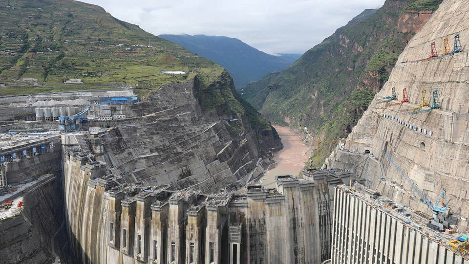
The world’s largest dam is rising in one of the world’s most geopolitically treacherous and seismically unstable regions, prompting urgent calls for international intervention. Just a few kilometers from the heavily militarized border with India, China is undertaking an unprecedented hydropower project in Tibet on the Yarlung Tsangpo, the world’s highest-altitude major river, internationally known as the Brahmaputra. This colossal undertaking, poised to dwarf China’s Three Gorges Dam in power-generating capacity, has ignited a firestorm of concern among scientists, downstream nations, and international observers, particularly as alarming geological hazards are being highlighted by China’s own scientific establishment. With the livelihoods of two billion people hanging in the balance, the international community faces a critical juncture to address this burgeoning environmental and humanitarian threat.
The Genesis of a Colossal Undertaking
The Yarlung Tsangpo, a river of immense significance and dramatic geological passage, embarks on its journey from the Tibetan Plateau. At the Great Bend, it plunges through what is recognized as the world’s deepest and longest canyon, a region of breathtaking natural grandeur and profound geological complexity. It is within this geologically volatile area that China has commenced the construction of a hydropower project of unparalleled scale. The dam’s reservoir is projected to impound a gargantuan volume of water, with potentially devastating consequences for millions of people residing downstream in India’s northeastern states and in the low-lying deltaic regions of Bangladesh, much of which lies perilously close to sea level.
The strategic rationale behind such a monumental dam is multifaceted, rooted in China’s expansive energy demands and its broader geopolitical ambitions. The Yarlung Tsangpo offers immense hydropower potential, and harnessing it aligns with China’s stated goals of increasing renewable energy production and reducing reliance on fossil fuels. However, the chosen location is fraught with inherent risks, situated squarely within the volatile Himalayan seismic belt, a zone characterized by the slow-motion collision of the Indian and Eurasian tectonic plates. This geological setting is among the most earthquake-prone on Earth, with a history of producing devastating seismic events.
Scientific Alarms from Within: A Troubling Revelation
The most pressing and perhaps most concerning warnings are emanating not from external critics, but from within China’s own scientific community. A recent, pivotal paper published in the state-linked, Mandarin-language journal Sedimentary Geology and Tethyan Geology has illuminated the profound geological hazards present at the dam’s construction site. The research, conducted by Chinese geologists, concludes that the terrain exhibits a "loose structure and weak cohesion." This assessment carries dire implications, as the scientists explicitly warn that fault movement or an earthquake could easily trigger large-scale instability, posing a catastrophic threat to both the reservoir and the surrounding infrastructure.
The authors of the paper have not minced words in their recommendations, advocating for the urgent reinforcement of reservoir slopes, the installation of robust retaining structures, and a fundamental redesign of key project elements to mitigate the risk of a catastrophic failure. These are not minor adjustments; they represent a stark acknowledgment of the inherent dangers embedded in the project’s current design and location. When scientists operating under a communist regime issue such unequivocal warnings, particularly concerning a project of such immense national importance and scale, the international community is compelled to pay serious attention.
The Specter of Reservoir-Triggered Seismicity
The danger associated with this mega-dam extends far beyond the immediate threat of an earthquake damaging its structure. A critical concern is the phenomenon of reservoir-triggered seismicity (RTS), a scientifically documented risk where the immense weight of water stored in a large reservoir can intensify geological stresses along underlying fault lines, potentially inducing seismic activity. This phenomenon has been observed and studied for decades, with significant case studies providing cautionary tales.
A particularly relevant and tragic example is believed to have occurred in China itself. The devastating earthquake that struck the Tibetan Plateau’s eastern rim in 2008, killing nearly 90,000 people, primarily in Sichuan province, has been a subject of intense scientific debate regarding its precise cause. While the exact relationship remains under scrutiny, influential research has concluded that the immense weight of water impounded by the Zipingpu Dam, a significant hydropower project completed just prior to the earthquake, may have increased pressure along a pre-existing fault. This increased pressure is theorized to have potentially advanced the timing of the earthquake by decades, if not centuries. This stark precedent underscores the amplified risk when constructing an even larger dam in a more geologically sensitive area, as is the case with the Yarlung Tsangpo project.
Transboundary Catastrophe: A Risk Unbound by Borders
The Himalayan fault system, a complex and interconnected web of geological forces, does not recognize national boundaries. Consequently, the potential consequences of a major dam failure in this region would not be confined to Chinese territory. The profound interconnectedness of this seismic zone was vividly demonstrated by the powerful 2025 Myanmar earthquake. Tremors from this event traveled significant distances, strong enough to trigger the collapse of a high-rise building in Bangkok, a city located approximately 1,000 kilometers away. This event serves as a stark reminder of how seismic activity in the Himalayas can have far-reaching and unexpected repercussions across the region.
The Brahmaputra River is the vital lifeblood of northeastern India, playing a critical role in irrigating agricultural lands, sustaining vital fisheries, replenishing wetlands, and supporting the livelihoods of millions. Its journey continues into Bangladesh, where it serves as the single largest source of freshwater, crucial for its vast population and delicate deltaic ecosystem. The construction of the Yarlung Tsangpo super-dam, akin to China’s extensive dam-building activities on the Mekong River, poses a significant threat to these downstream nations. It has the potential to drastically alter cross-border river flows, reduce the transport of nutrient-rich sediment essential for the river’s ecological health, and negatively impact the agricultural productivity of riparian countries.
The most alarming prospect is the potential for a catastrophic structural failure of the dam, or even an emergency release of impounded water following seismic damage. Such an event could unleash devastating floods across densely populated downstream plains with little to no warning. What begins as an engineering failure in Tibet could rapidly escalate into a humanitarian catastrophe, extending its devastating reach all the way to Bangladesh, the world’s most densely populated country outside of microstates and mini-states.
Water as a Geopolitical Weapon: China’s Strategic Leverage
Beyond the immediate geological and humanitarian risks, China’s ambitious dam project is deeply intertwined with its broader strategy of transforming its control over the Tibetan Plateau into a tool of geopolitical leverage. The Tibetan Plateau is the source of most of Asia’s major rivers, and China’s extensive dam construction on transboundary rivers has become a significant concern for downstream nations. Reports indicate that China has a history of withholding vital hydrological data, particularly during periods of geopolitical tension, and has consistently resisted entering into formal water-sharing treaties with its neighbors. This has led to concerns that water is increasingly being weaponized as an instrument of coercive statecraft.
The sheer scale of what China has termed "the project of the century" will inevitably grant it unprecedented control over vital river flows. Even routine reservoir operations can have profound impacts on downstream ecosystems, agricultural practices, sediment transport, and natural flood patterns. The lack of transparency surrounding the project only exacerbates these concerns. Despite the enormous transboundary implications, the Chinese government has released remarkably little technical information. There has been a conspicuous absence of meaningful environmental transparency, no independent geological review of the site, and crucially, no credible consultation with the countries that stand to face the greatest downstream risks.
International Law and the Imperative for Transparency
International law has long recognized the inherent responsibilities of states that share transboundary rivers. These principles include the obligation to prevent significant cross-border harm, the imperative to exchange relevant information, and the necessity of consulting on projects that could materially affect downstream neighbors. Adherence to these principles is fundamental to safeguarding shared water resources and fostering regional stability. China’s continued opacity surrounding the Yarlung Tsangpo dam project directly undermines these established norms and erodes trust among riparian nations.
The Himalayan watershed, often referred to as Asia’s "water tower," is a critical source of freshwater for nearly two billion people across a multitude of countries. The introduction of the world’s largest dam into this inherently fragile ecosystem, coupled with a deliberate lack of transparency, transforms a potential engineering project into a significant regional security risk.
A Call for Independent Scrutiny and Cooperation
Given the extraordinary stakes involved, a strong case can be made for China to immediately invite an independent panel of international experts to assess the project. This panel should comprise leading seismologists, geologists, and dam-safety specialists. Their mandate would be to rigorously inspect the construction site, critically review the project’s geological assumptions, and independently assess whether the design modifications recommended by Chinese geologists are indeed sufficient to mitigate the identified risks.
Furthermore, China should move beyond its current stance of opacity and actively work to institutionalize year-round, real-time hydrological data-sharing with India and Bangladesh. Establishing robust emergency notification mechanisms is also paramount. Crucially, China must commit to ongoing, meaningful transboundary consultations on any major design changes or operational adjustments that could impact downstream water availability and flow.
The irony of the current situation is profound. The latest evidence suggests that China’s own scientific establishment possesses a clearer understanding of the inherent dangers posed by this mega-dam than its political leadership may be willing to publicly acknowledge. Now that China’s own geologists have sounded the alarm, it is imperative for policymakers to embrace transparency, uphold international legal principles, and accept their transboundary responsibilities. The world watches, hoping that this potential "water bomb" upstream is defused through cooperation and a commitment to shared security and environmental stewardship, rather than being allowed to detonate with catastrophic consequences for millions.
