

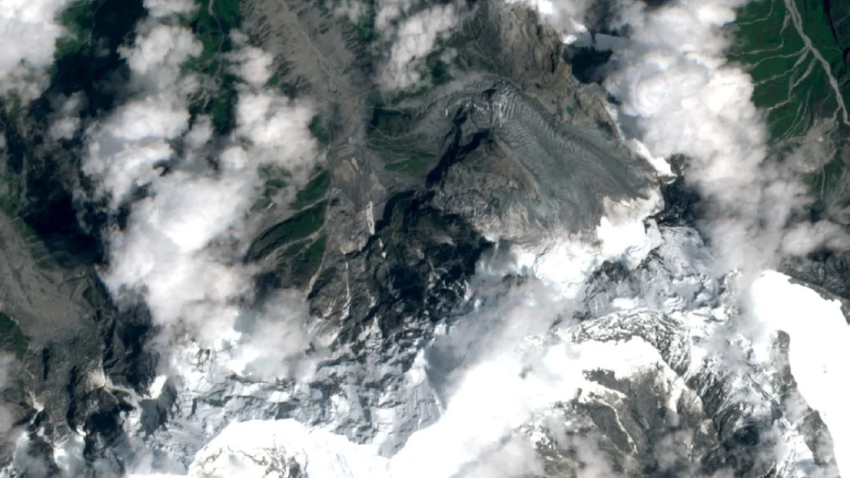
A catastrophic high-altitude ice-rock avalanche originating in the Nepalese Himalayas has triggered a massive debris flow and flash flood, leaving a trail of destruction across the border into China’s Tibet Autonomous Region. As of Thursday afternoon, local authorities and rescue teams have confirmed nearly 300 deaths, while more than 1,000 individuals remain missing in the rugged terrain of Gyirong County and surrounding areas. The disaster has sent shockwaves through the international scientific community, coming just as researchers were highlighting the successes of a joint China-Nepal disaster mitigation network designed to prevent such tragedies.
The event began on Wednesday when a massive section of ice and rock collapsed at a high altitude within Nepal’s mountainous interior. The resulting kinetic energy transformed the falling debris into a high-velocity flow that struck a local river system. The surge of water, mud, and boulders gained momentum as it funneled through steep valleys, eventually crossing the international border and inundating downstream settlements in Tibet’s Gyirong County. The scale of the devastation has raised urgent questions regarding the efficacy of current monitoring technologies in the face of increasingly volatile mountain environments.
A Sudden and Violent Descent
The disaster was not a typical glacial lake outburst flood (GLOF), a phenomenon that regional scientists have spent decades studying and monitoring. Instead, experts suggest the primary trigger was a glacial rock collapse—a sudden structural failure of the mountain itself. Unlike the gradual pressure buildup associated with rising lake levels, an ice-rock avalanche occurs with almost no visible warning, releasing immense gravitational potential energy in seconds.
According to a glaciologist from a research institute in Chengdu, Sichuan province, these events are significantly more destructive than standard GLOFs. Speaking to the Southern Weekly on Thursday, the expert noted that high-altitude avalanches involve a complex mixture of solid rock, glacial ice, and water, creating a dense slurry that can plane down forests, destroy reinforced concrete infrastructure, and alter the course of rivers instantaneously.
The debris flow moved with such speed that residents in Gyirong County had little time to seek higher ground. Initial reports indicate that several small villages and temporary settlements used by nomadic herders and border workers were almost entirely erased. Rescue operations have been hampered by the destruction of key mountain roads and the continued instability of the surrounding slopes.
The Irony of Scientific Progress
The tragedy unfolded against a backdrop of what appeared to be a major milestone in regional disaster prevention. On the same day the avalanche struck, a team of scientists from the Chinese Academy of Sciences (CAS) published a paper in the peer-reviewed Journal of Glaciology and Geocryology. The paper, led by researcher Wang Weicai, detailed the successful implementation of a sophisticated monitoring and early warning network across the Himalayan range.
The scientific team highlighted several key achievements, including the establishment of a monitoring network under the Second Qinghai-Tibet Scientific Expedition. This network specifically targeted high-risk zones such as the Sedongpu area of the Yarlung Tsangpo River and the Cirenma Co glacial lake in the China-Nepal cross-border basin. The paper proudly noted that these systems had successfully issued seven early warnings in recent years, including a critical alert at the China-Nepal border last year that was credited with saving numerous lives.
However, the Wednesday disaster appears to have bypassed these specific sensors or occurred in a zone not yet fully integrated into the real-time alert system. It remains unclear whether the China-Nepal early warning system detected any seismic or thermal anomalies prior to the collapse. The South China Morning Post has reached out to Wang Weicai and the CAS for clarification on whether the system was active in the specific valley where the avalanche originated, but a formal response has not yet been provided.
Chronology of the Disaster
The timeline of the event highlights the rapid transition from a localized geological failure to a regional humanitarian crisis:
- Wednesday Morning: A massive ice and rock mass becomes unstable at an undisclosed high-altitude location in the Nepalese Himalayas.
- Wednesday Midday: The collapse occurs, sending millions of cubic meters of debris into a tributary river. The resulting flash flood begins its descent toward the Chinese border.
- Wednesday Afternoon: The flood wave enters Gyirong County, Tibet. Communications are severed in several remote townships as the water destroys telecommunications infrastructure.
- Wednesday Evening: Initial reports of missing persons reach regional administrative centers. Emergency response protocols are activated by the Tibetan regional government.
- Thursday Morning: Aerial surveys reveal the extent of the damage. Large swathes of valley floor are covered in silt and boulders. Search and rescue teams begin discovering casualties.
- Thursday Afternoon: Official tolls are updated to nearly 300 confirmed dead and over 1,000 missing. The scientific paper praising the region’s early warning systems circulates among the global academic community, highlighting a tragic gap between current capabilities and the unpredictability of nature.
The Challenges of the "Third Pole"
The Himalayas, often referred to as the "Third Pole" due to the vast amount of glacial ice they hold, are currently undergoing rapid transformation. Climate change has led to accelerated glacial retreat, which in turn destabilizes the rock walls that were previously supported by ice. This "de-buttressing" effect makes the region increasingly prone to large-scale collapses.
Supporting data from recent geological surveys indicates that the number of "high-risk" glacial lakes in the Himalayas has increased by over 20% in the last two decades. While the China-Nepal monitoring network has made significant strides in tracking these lakes, the "ice-rock avalanche" remains a much more elusive threat. These events are often triggered by deep-seated permafrost thaw or internal tectonic stresses that are difficult to monitor via satellite or surface-level sensors alone.
The Cirenma Co glacial lake, mentioned in the CAS paper, is a prime example of the complexities involved. Located in the Sun Koshi basin, it has a history of devastating outbursts (most notably in 1964 and 1981). While the joint early warning system has successfully managed the risks associated with this specific lake, the broader Himalayan terrain contains thousands of unmonitored slopes that pose a similar, if not greater, threat.
Humanitarian and Infrastructure Impact
The impact on Gyirong County is particularly significant given its role as a vital economic artery. Gyirong Port is one of the primary land gateways for trade between China and Nepal. The flash flood has reportedly damaged sections of the highway connecting the border to Shigatse, Tibet’s second-largest city, potentially disrupting bilateral trade for months.
Local officials in Tibet have deployed thousands of personnel, including paramilitary forces and medical teams, to the affected areas. However, the geographic isolation of the region means that heavy machinery required to clear debris must be transported over high-altitude passes that are themselves prone to landslides during the current monsoon season.
In Nepal, the government has declared a state of emergency in the affected districts. Prime Minister-level statements have expressed condolences and called for increased international cooperation in mountain safety. The disaster underscores the shared vulnerability of the two nations, which are bound together by the treacherous geography of the world’s highest mountain range.
Future Implications for Disaster Mitigation
This event is likely to prompt a significant re-evaluation of how mountain hazards are monitored. While the current focus has been on Glacial Lake Outburst Floods (GLOFs), the "ice-rock avalanche" represents a "black swan" event that requires a different set of diagnostic tools.
Future scientific efforts may need to incorporate:
- InSAR (Interferometric Synthetic Aperture Radar): To detect millimeter-scale movements in rock faces before they fail.
- Enhanced Seismic Arrays: To identify the unique "micro-seismic" signatures of internal glacial fracturing.
- Cross-Border Data Integration: Ensuring that sensors on the Nepalese side can trigger automated sirens and SMS alerts on the Chinese side (and vice versa) within seconds.
The tragedy also highlights the limitations of academic optimism. While the paper published on Wednesday was correct in celebrating the seven lives saved by previous warnings, the 1,300 victims of this latest event serve as a sobering reminder that the scientific community is in a race against a changing climate.
As recovery efforts continue, the focus will shift from immediate rescue to long-term reconstruction and the hardening of infrastructure. For the families of the 1,000 missing, the wait for news continues in a landscape that has been irrevocably altered. The disaster stands as a testament to the raw power of the Himalayas and the urgent need for a more comprehensive, all-encompassing approach to high-altitude disaster prevention.
