

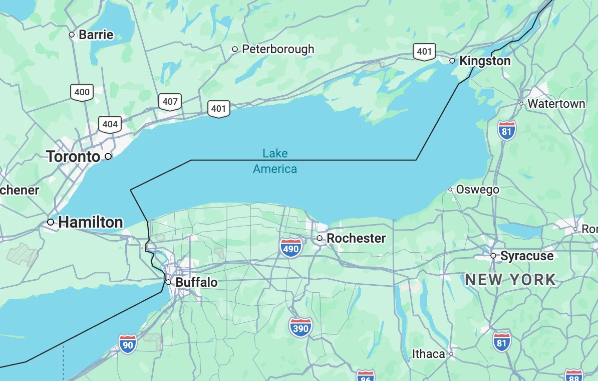
Google has officially updated its digital mapping platform to rename Lake Ontario as "Lake America" for users within the United States, a move that follows an executive order issued by President Donald Trump earlier this week. The change, which appeared on the platform late Saturday, represents the latest development in a series of administrative actions aimed at rebranding significant geographic features shared with international neighbors. The rebranding follows a directive from the White House that ordered the Department of the Interior to update all official government databases, roadway signage, and federal literature to reflect the new nomenclature as part of a broader strategy involving trade negotiations and national identity.
The executive order, signed on Thursday, is rooted in an escalating diplomatic and economic dispute between the United States and Canada. President Trump cited ongoing disagreements over trade tariffs and dairy quotas as the primary motivation for the change, specifically targeting the name "Ontario," which is also the name of Canada’s most populous province. This administrative action mirrors a similar move made in January 2025, when the administration ordered the renaming of the Gulf of Mexico to the "Gulf of America" during a period of heightened tension regarding border security and trade with Mexico.
The Mechanism of Digital Map Updates
The rapid adoption of "Lake America" by Google Maps highlights the intricate relationship between private technology companies and federal data repositories. While private entities like Google, Apple, and Microsoft are not legally compelled to adopt federal naming conventions for their consumer-facing products, they historically rely on the Geographic Names Information System (GNIS) maintained by the U.S. Geological Survey (USGS). The GNIS serves as the nation’s official repository of domestic geographic names information.
On Saturday evening, the Department of the Interior updated the GNIS records to reflect the "Lake America" designation. Following this update, Google’s algorithms, which are designed to sync with official government data to ensure accuracy for logistics, emergency services, and navigation, began rolling out the change. A spokesperson for Google confirmed that the update is being implemented through a process known as "geofencing" or "geographic localization."
Under this policy, the naming convention a user sees is determined by their physical location or IP address. Users accessing Google Maps from within the United States will see the body of water labeled as "Lake America." Conversely, users in Canada will continue to see "Lake Ontario," while international users in third-party countries will likely see a dual-labeling system or a primary name accompanied by the alternative in parentheses. This approach is consistent with how mapping providers handle other internationally disputed territories or bodies of water with multiple recognized names, such as the Sea of Japan (East Sea) or the Persian Gulf (Arabian Gulf).
Chronology of Geographic Rebranding (2025)
The rebranding of Lake Ontario is the second major geographic name change of 2025, signaling a shift in how the executive branch utilizes nomenclature as a tool of foreign policy.
- January 12, 2025: President Trump issues an executive order to rename the Gulf of Mexico as the "Gulf of America," citing the need to "reclaim the American coastline."
- January 25, 2025: The Department of the Interior completes the update of federal databases for the Gulf region. Google and Apple Maps adopt the "Gulf of America" name for U.S.-based users shortly thereafter.
- March 20, 2025: Tensions rise between the U.S. and Canada over new steel and aluminum tariffs.
- March 27, 2025 (Thursday): The White House issues an executive order rebranding Lake Ontario as "Lake America," specifically noting the name’s association with the Canadian province of Ontario.
- March 29, 2025 (Saturday): Federal databases are updated. Google Maps reflects the change for domestic users by late evening.
- March 30, 2025 (Sunday): The GNIS public portal displays a notice that maps are "in the process of being updated to reflect this name change."
Economic and Trade Context
The renaming of Lake Ontario is inextricably linked to the current state of North American trade relations. Lake Ontario is the easternmost of the Great Lakes and serves as a vital artery for the St. Lawrence Seaway, a massive hydraulic system that allows ocean-going vessels to reach the industrial heartland of North America. The Great Lakes region as a whole supports a $6 trillion economy, and the shared management of these waters has been a cornerstone of U.S.-Canada relations for over a century.
The President’s order comes on the heels of a "Buy American" push that has expanded into the realm of cartography. Administration officials have argued that since a significant portion of the lake’s southern shoreline belongs to the state of New York, the name should reflect American sovereignty rather than Canadian provincial identity. The move is seen by trade analysts as a "symbolic tariff," intended to exert pressure on Canadian Prime Minister Justin Trudeau’s government during negotiations over the United States-Mexico-Canada Agreement (USMCA) framework.
Divergent Responses from Tech Providers
While Google has moved quickly to align with federal data, other tech giants and mapping organizations have shown varying degrees of compliance.
Apple and Microsoft
As of Sunday morning, Apple Maps and Bing Maps (owned by Microsoft) had not yet updated their labels to "Lake America." However, industry insiders expect these platforms to follow suit within the coming days. Both companies utilize federal data for their base maps, particularly for search and rescue functions and aviation software, where naming consistency with government air traffic control and maritime records is essential.
MapQuest
In a notable departure from the industry trend, MapQuest issued a brief statement via social media asserting that they would not be adopting the new name. "MapQuest prides itself on cartographic stability. We are not changing it," the company stated. This move has positioned MapQuest as a preferred alternative for users and organizations that oppose the rebranding.
OpenStreetMap (OSM)
The open-source mapping community, which powers apps like Uber, Lyft, and Foursquare, has engaged in a heated internal debate. Because OSM relies on a global community of volunteer editors, the "Lake America" change has been the subject of "edit wars," where some users change the name to match the U.S. executive order while others revert it to the historical name. Currently, OSM’s policy is to recognize both names in its underlying metadata, allowing developers who use their API to choose which version to display based on their own internal guidelines.
Diplomatic and Legal Implications
The rebranding has drawn sharp criticism from Canadian officials and international cartographic societies. The Premier of Ontario released a statement calling the move "unprecedented and unhelpful," noting that "Lake Ontario has held its name for centuries, derived from the Wyandot (Iroquois) word Skanadario, meaning ‘sparkling water.’ It is a name rooted in the indigenous history of the region, not just modern politics."
Legal experts have pointed out that while the President has broad authority over federal agencies like the USGS and the Department of the Interior, his power to change names internationally is limited. The Boundary Waters Treaty of 1909 established the International Joint Commission (IJC) to manage the Great Lakes. Critics argue that unilateral naming changes violate the spirit of this long-standing binational cooperation.
"Geography is usually considered a matter of objective fact and historical consensus," said Dr. Elena Rodriguez, a senior fellow at the Institute for International Cartography. "When geographic naming becomes a tool of short-term political maneuvering, it creates significant confusion for international shipping, environmental research, and cross-border emergency response coordination."
Impact on Navigation and Infrastructure
The practical implications of the name change extend beyond digital screens. The Department of Transportation (DOT) has already begun the process of auditing highway signs in upstate New York. Thousands of signs along the I-90 and I-81 corridors that mention "Lake Ontario" or the "Lake Ontario State Parkway" will eventually need to be replaced or modified to reflect the "Lake America" designation to remain consistent with federal travel grants and mapping requirements.
Furthermore, the maritime industry faces a period of transition. While international maritime charts are often governed by the International Hydrographic Organization (IHO), U.S.-flagged vessels and domestic ports are required to use federal nomenclature. This could lead to discrepancies in logbooks and communication between U.S. and Canadian coast guards, who share search-and-rescue responsibilities on the lake.
Analysis of the "Americanization" of Geography
The renaming of Lake Ontario represents a broader trend in the current administration’s approach to "Americanizing" the domestic landscape. By shifting from names with foreign or colonial origins to "America"-centric titles, the administration seeks to reinforce a sense of national unity and territorial pride. However, this strategy also risks isolating the United States from its traditional allies.
The transition of "Lake Ontario" to "Lake America" on Google Maps serves as a potent reminder of the power of digital platforms to reshape our perception of the physical world. As more users rely on a handful of tech companies for their understanding of geography, the decisions these companies make—whether to follow government mandates or uphold cartographic tradition—have profound consequences for how we define the world around us. For now, the "sparkling water" of the eastern Great Lakes remains a site of both natural beauty and intense political friction, known by one name to the north and another to the south.
