

The Critical Need for Intersection Innovation
The modern transportation landscape in the United States faces a dual crisis of safety and efficiency. According to data from the National Highway Traffic Safety Administration (NHTSA) and the Federal Highway Administration (FHWA), more than 40,000 fatalities occur on American roads every year, resulting in approximately $300 billion in economic damages. Intersections represent the most dangerous nodes in this network; despite occupying a small fraction of total road mileage, they account for nearly 25% of all traffic fatalities and approximately 50% of all traffic-related injuries.
Beyond the human cost, the financial and environmental impact of inefficient traffic management is staggering. Traditional traffic signal systems often rely on pre-set timers or basic inductive loop sensors buried in the pavement, which lack the sophistication to respond to real-time fluctuations. This leads to "ghost idling"—vehicles sitting at red lights at empty intersections—and stop-and-go patterns that significantly increase fuel consumption and greenhouse gas emissions. The FHWA estimates that optimizing signal timing alone can reduce traffic delays by 15% to 40% and cut fuel consumption by up to 10% in urban corridors.
"A substantial share of crashes and excess fuel consumption are associated with intersections," noted Stan Young, an advanced mobility specialist at NLR. "It’s a persistent challenge that, until recently, was difficult to solve due to the limitations of isolated sensor technologies."
IPC-Fusion: A Digital Twin of Intersection Activity
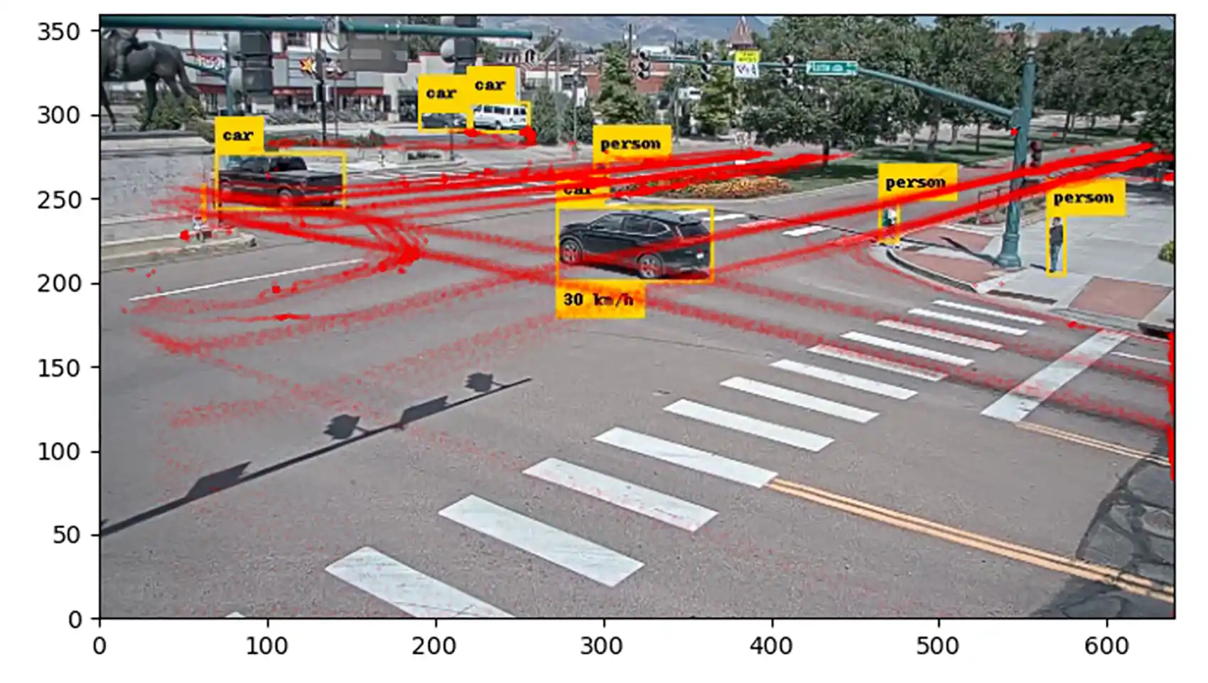
At the core of the NLR’s solution is IPC-Fusion, an open-source toolkit designed to create a "digital twin" of an intersection. A digital twin is a virtual, real-time representation of a physical asset or process. In this context, it is a high-fidelity model that tracks every vehicle, pedestrian, and cyclist within the intersection’s footprint with millimetric precision.
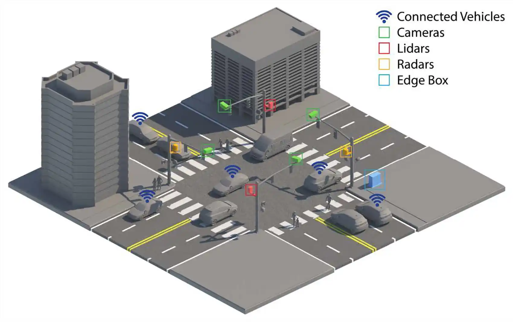
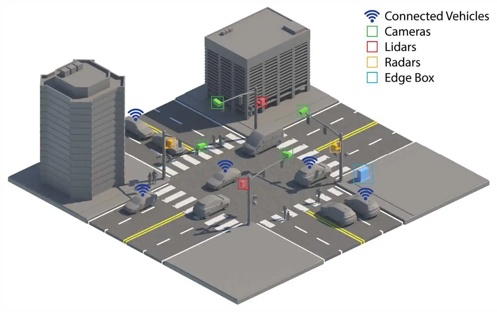
The IPC (Infrastructure Perception and Control) framework achieves this by fusing "object-level" information from a diverse array of hardware:
- Video Cameras: AI-enabled cameras identify and classify objects, such as distinguishing between a delivery van and a cyclist.
- Lidar (Light Detection and Ranging): Lidar provides precise 3D spatial mapping, allowing the system to "see" distances and shapes even in challenging lighting conditions.
- Radar: Radar is highly effective at measuring the velocity of approaching vehicles and operates reliably in adverse weather like fog or heavy rain.
- Connected Vehicle Data: Information transmitted directly from modern vehicles provides internal telemetry, such as braking intensity and turn signal status.
By combining these streams, IPC-Fusion eliminates the "blind spots" inherent in using a single sensor type. If a camera is obscured by a large truck, the lidar or radar can still track a pedestrian behind that truck, ensuring the traffic management system has a complete operational picture.
Chronology of Development and Field Validation
The journey of IPC-Fusion from a laboratory concept to a field-ready toolkit followed a rigorous developmental timeline. The project was spearheaded by NLR’s Infrastructure Perception and Control Laboratory, a facility dedicated to integrating advanced sensing and optimization techniques for intelligent transportation systems.
- Conceptualization and Lab Testing: Initial research focused on the mathematical challenge of "data fusion"—the process of reconciling different data formats and timestamps from various sensors into a single, cohesive model. Researchers had to ensure the system could run on "edge devices," which are compact computers installed at the intersection with limited processing power compared to massive data centers.
- Prototype Development: The team developed the IPC-Fusion toolkit using a combination of artificial intelligence, machine learning, and classical statistical methods. This hybrid approach allowed for high-speed processing while maintaining the reliability of traditional physics-based models.
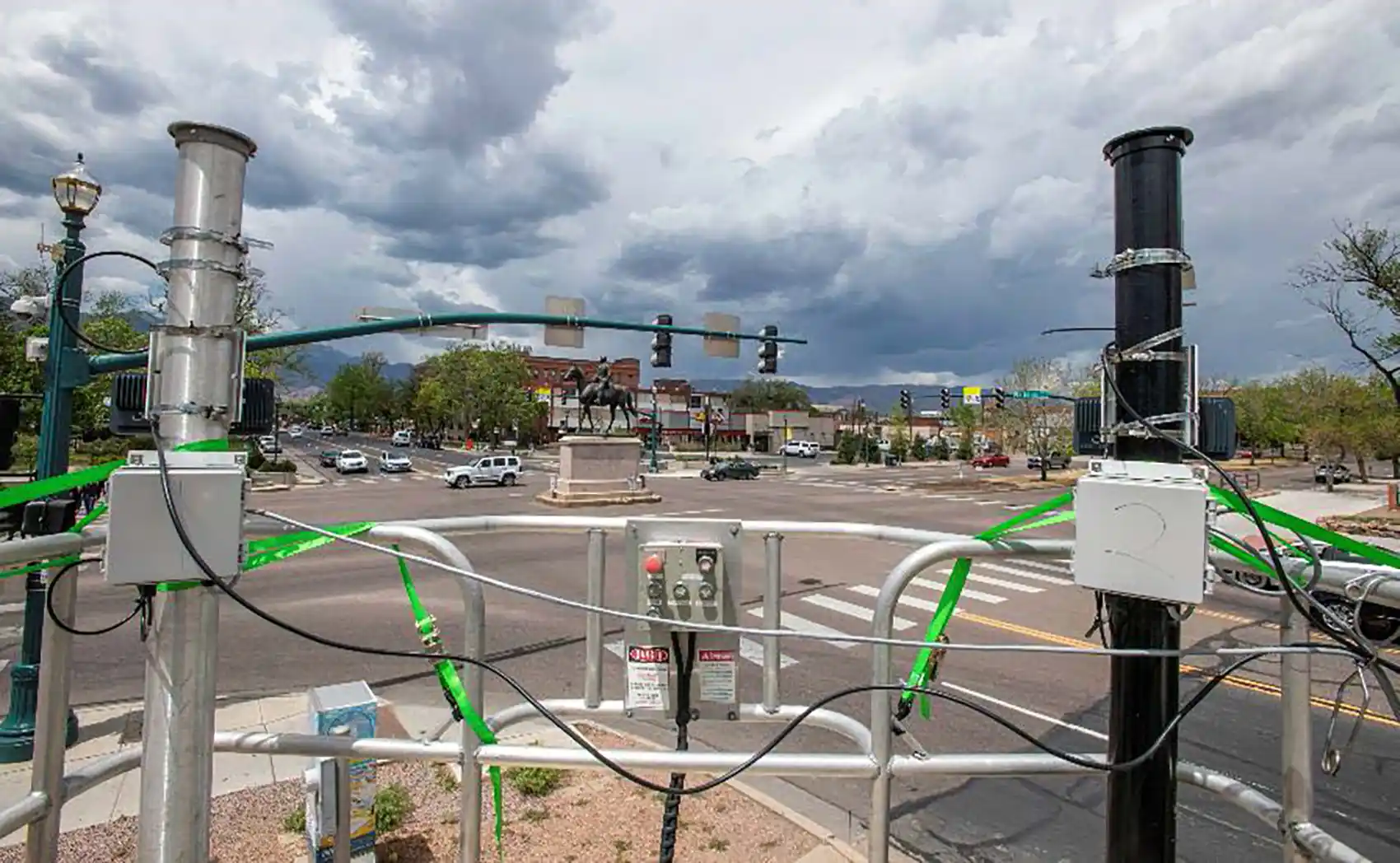
- Field Demonstrations in Colorado: The system underwent extensive real-world validation at operational intersections in Colorado Springs and Lakewood, Colorado. Researchers equipped NLR’s mobile laboratory—a vehicle outfitted with an array of sensors—to gather comparative data.
- Data Repository Release: To support the broader scientific community, NLR developed a repository of object-level trajectory data. This remains one of the few publicly available datasets that includes both infrastructure sensor data and connected vehicle telemetry.
- Licensing and Commercialization: Following successful demonstrations, the toolkit was made available for licensing. NLR is currently in negotiations with a major traffic solutions provider to integrate IPC-Fusion into commercial traffic controllers used by cities worldwide.
Technical Breakthroughs in Data Integration
One of the primary hurdles in modern traffic management is "vendor lock-in." Many sensor manufacturers use proprietary data formats, making it difficult for a city to combine a camera from one company with a lidar sensor from another. IPC-Fusion addresses this by being "sensor-agnostic" and "vendor-agnostic."
Rimple Sandhu, an NLR computational scientist, explained the complexity of the task: "Fusing object-level information from diverse sources in real time is a challenging mathematical endeavor. Our goal was to build a framework able to operate across different sensor types and connect through infrastructure-to-everything (I2X) communications with high reliability."
The toolkit uses standardized data interfaces, which simplifies the integration of future technologies. As better sensors are developed, municipalities can upgrade their hardware without needing to overhaul the entire software backend. This flexibility is a critical financial consideration for departments of transportation (DOTs) operating on multi-year budget cycles.
Real-World Implications for Safety and Efficiency
The practical applications of a real-time digital twin are far-reaching. For a typical commuter, this technology means fewer minutes spent idling at red lights. The system can detect when a single vehicle is waiting at a side street and adjust the main road’s signal timing dynamically, rather than forcing the driver to wait for a pre-timed cycle to complete.
From a safety perspective, the implications are even more profound. The system can:
- Extend Pedestrian Intervals: If the sensors detect a person with limited mobility or a group of children still in the crosswalk, the system can automatically hold the red light for cross-traffic.
- Identify High-Risk Behavior: By tracking patterns of "harsh braking" or frequent red-light running, transportation agencies can identify dangerous intersections before a fatal crash occurs. This allows for proactive engineering interventions, such as changing signal visibility or adjusting speed limits.
- Emergency Response: The system can prioritize emergency vehicles, creating a "green wave" that allows ambulances and fire trucks to navigate through congested urban centers more safely and quickly.
Broader Impact: From Intersections to Smart Cities
The research conducted at the NLR’s Infrastructure Perception and Control Laboratory extends beyond just traffic lights. The AI and data fusion techniques are being applied to several other critical transportation challenges:
Standardizing Road Hazard Data:
One of the most difficult tasks for autonomous vehicles and human drivers alike is navigating shifting road conditions. NLR is using AI to fuse disparate data sources—such as maintenance logs, construction permits, and emergency radio feeds—into standardized, machine-readable streams. This ensures that every vehicle on the road has real-time information about hazards or closures.
The National Microtransit Dashboard:
Microtransit—small fleets of on-demand minivans—has become a popular solution for "first-mile/last-mile" connectivity. However, these services often operate in silos. NLR is utilizing large language models (LLMs) to assemble a national database of these operations, helping urban planners track their impact and helping travelers find available services.

Sentiment Analysis for Future Mobility:
As "robotaxis" and autonomous shuttles become more common, public perception remains a hurdle. NLR researchers are using AI-enabled sentiment analysis to track user responses to these technologies, assessing everything from safety concerns to user satisfaction at major airports.
Conclusion: Laying the Foundation for Automated Mobility
The development of IPC-Fusion marks a significant step toward the "Smart City" of the future. By providing a common, high-accuracy understanding of road conditions, this technology lays the essential groundwork for fully automated mobility. In a future where vehicles and infrastructure communicate seamlessly, the risk of human error—the leading cause of traffic accidents—could be virtually eliminated.
For now, the immediate benefits of the IPC-Fusion framework offer a clear "win-win" for society. It provides a cost-effective way for cities to maximize the value of their existing infrastructure, reducing the need for massive capital investments in new lanes or overpasses. By focusing on the "intelligence" of the intersection, researchers at the National Laboratory of the Rockies are proving that data, rather than just asphalt, is the key to a safer, more efficient transportation future. As this technology scales from pilot programs in Colorado to cities across the nation, the result will be measured in minutes saved, gallons of fuel conserved, and, most importantly, lives protected.
